Showing posts with label USA. Show all posts

Saturday, October 6, 2012

Canyonlands National Park

Canyonlands National Park is a U.S. National Park located in southeastern Utah near the town of Moab and preserves a colorful landscape eroded into countless canyons, mesas and buttes by the Colorado River, the Green River, and their respective tributaries. The park is divided into four districts: the Island in the Sky, the Needles, the Maze, and the rivers themselves. (Read more at Wikipedia) 


Friday, October 5, 2012

Things to see in Arches National Park

Arches National Park is a U.S. National Park in eastern Utah. It is known for preserving over 2000 natural sandstone arches, including the world-famous Delicate Arch, in addition to a variety of unique geological resources and formations. The park is located just outside of Moab, Utah, and is 76,679 acres  in area.


Among the notable arches are :

Delicate Arch – a lone-standing arch which has become a symbol of Utah
Double Arch – two arches that share a common end
Landscape Arch – a very thin and long arch with a span of 290 feet (88 m)
Wall Arch – located along the popular Devil's Garden Trail.
Skyline Arch - located along 

Things to See : 
Balanced Rock – a large balancing rock, the size of three school buses
Courthouse Towers – a collection of tall stone columns
Dark Angel – a free-standing 150-foot tall sandstone pillar at the end of the Devil's Garden Trail
Fiery Furnace – an area of maze-like narrow passages and tall rock columns
Petrified dunes – petrified remnants of sand dunes blown from the ancient lakes
Devil's Garden – with many arches and columns scattered along a ridge


I also send this cover to my friends.

2) ?

This cover has 34 cents stamps issued in 2002 "Greeting from America" (UTAH, where park is located). This stamp has Arches, flower and mountain lion.!!


THINGS TO DO : ( I did it all of the following)

Balanced Rock Hiking : A loop trail around the base of a fragile, picturesque rock formation.
Length: 0.3 mi/0.5 km round trip
Time: 15 to 30 minutes


The Windows :A gentle climb up a gravel loop trail leads to three massive arches (North and South Windows and Turret Arch). An alternate return, slightly longer, is by way of the primitive loop around the back of the two Windows. The primitive loop trail starts at the South Window viewpoint.
Length: 1 mile (1.6 km) round trip
Time: 30 to 60 minutes


Double Arch : A relatively flat, sandy trail leads to the base of two giant arch spans which are joined at one end.
Length: 0.5 mile (0.8 km) round trip
Time: 15 to 30 minutes


Skyline Arch : We did partial hike as it was so hot. A short hike on a flat, well-defined trail.
Length: 0.4 mile (0.6 km) round trip
Time: 10 to 20 minutes


Sand Dune Arch : Trail leads through deep sand to a secluded arch among sandstone fins. (Hike for little kids.)
Length: 0.4 mile (0.6 km) round trip
Time: 15 to 30 minutes


Broken Arch : We saw this while hiking Sand Dune Arch.

Landscape Arch : A relatively flat, gravel-surfaced trail (usually heavily populated with hikers) leads to a spectacular ribbon of rock, whose span is more than a football field in length. Short side trips to Tunnel and Pine Tree Arches. Trail guide available at trailhead.
Length: 1.6 miles (2.4 km) round trip
Time: 30 to 60 minutes

Delicate Arch Hike : Most Popular trail and must hike for photographers. (Starts from Wolfe Ranch parking area).
Length: 3 miles round trip (don't get lost and if you get lost don't try to hike the arch. it's very risky.!!)
Time: 2 hours
Note : In addition to this there are other two viewpoint 100 yards round trip and another (moderately strenuous) hiking trail climbs one-half mile (0.8 km) toward Delicate Arch and ends at the rim of a steep canyon that separates the viewpoint from the arch.


Wednesday, October 3, 2012

Crazy Horse Memorial : World's Largest Sculpture in Progress.!!

The Crazy Horse Memorial is a mountain monument complex that is under construction on privately held land in the Black Hills, in Custer County, South Dakota. 


It depicts Crazy Horse, an Oglala Lakota warrior, riding a horse and pointing into the distance. The memorial was commissioned by Henry Standing Bear, a Lakota elder, to be sculpted by Korczak Ziolkowski. It is operated by the Crazy Horse Memorial Foundation, a private non-profit organization.

The memorial consists of the mountain carving (monument), the Indian Museum of North America, and the Native American Cultural Center. The monument is being carved out of Thunderhead Mountain on land considered sacred by some Oglala Lakota, between Custer and Hill City, roughly 17 miles from Mount Rushmore. 

The sculpture's final dimensions are planned to be 641 feet  wide and 563 feet high. The head of Crazy Horse will be 87 feet  high; by comparison, the heads of the four U.S. Presidents at Mount Rushmore are each 60 feet high.
The monument has been in progress since 1948 and is far from completion. If completed, it may become the world's largest sculpture, as well as the first non-religious statue to hold this record since 1967. The most recent is Russia's Mamayev Monument


This postcard has circular hand cancellation of Crazy Horse, SD.!!


Who was Crazy Horse : Crazy Horse was a Native American war leader of the Oglala Lakota. He took up arms against the U.S. Federal government to fight against encroachments on the territories and way of life of the Lakota people, including leading a war party to victory at the Battle of the Little Bighorn in June 1876. 

After surrendering to U.S. troops under General Crook in 1877, Crazy Horse was fatally wounded by a military guard while allegedly resisting imprisonment at Camp Robinson in present-day Nebraska. 

The Future of Crazy Horse :


Tuesday, October 2, 2012

Mount Rushmore : Things to do and look

The Mount Rushmore National Memorial is a sculpture carved into the granite face of Mount Rushmore near Keystone, South Dakota, in the United States. Sculpted by Danish-American Gutzon Borglum and his son, Lincoln Borglum, Mount Rushmore features 60-foot sculptures of the heads of former United States presidents  George Washington, Thomas Jefferson, Theodore Roosevelt and Abraham Lincoln.


Grant Entrance of Mount Rushmore National Memorial. 


I also send this cover tomy philatelic friends.

1) Japan : - http://jg2oaj.blogspot.jp/2012/08/cover-from-usa.html
2) ?
3) ?

Monday, October 1, 2012

Yellowstone National Park


World's Largest Collection of Geysers
It's wonderland. Old Faithful and the majority of the world's geysers are preserved here. They are the main reason the park was established in 1872 as America's first national park—an idea that spread worldwide. A mountain wildland, home to grizzly bears, wolves, and herds of bison and elk, the park is the core of one of the last, nearly intact, natural ecosystems in the Earth’s temperate zone

Following postcard was inside my hotel room ("Old Faithful Inn") and I mailed it to myself.!!


It has a special cancellation of OLD FAITHFUL STATION.!!


The Old Faithful Inn is a hotel located in Yellowstone National Park, Wyoming, United States, with a clear view of the renowned Old Faithful Geyser. The Inn features a multi-story log lobby, flanked by long frame wings containing guest rooms.

With its spectacular log and limb lobby and massive (500-ton, 85-foot) stone fireplace, the inn is a prime example of the "Golden Age" of rustic resort architecture, a style which is also known as National Park Service Rustic. It is also unique in that it is one of the few log hotels still standing in the United States. It was the first of the great park lodges of the American west.

Initial construction was carried out over the winter of 1903-1904, largely using locally-obtained materials including lodgepole pine and rhyolite stone. When the Old Faithful Inn first opened in the spring of 1904, it boasted electric lights and steam heat. (From Wikipedia)


The structure is the largest log hotel in the world; possibly even the largest log building in the world. In 2007 the American Institute of Architects conducted a survey to determine the 150 favorite buildings in America; the Old Faithful Inn ranked 36. The Inn, which was designated a National Historic Landmark in 1987, is itself part of the Old Faithful Historic District.


Uncle Tom's Trail was first constructed in 1898 by "Uncle" Tom Richardson. The five years following its construction, Uncle Tom led visitors on tours which included crossing the river upstream from the present day Chittenden Bridge, and then following his rough trail to the base of the Lower Falls. The tour was concluded with a picnic and a return trip across the river.

Today Uncle Tom's Trail is very different from the simple trail used by Mr. Richardson and his visitors. It is still, however, a very strenuous walk into the canyon. The trail drops 500 feet (150 m) in a series of more than 300 stairs and paved inclines.

Artist Point : The name Artist Point is believed to have been given to this location around 1883 by Park Photographer F. Jay Haynes. The name appeared in print for the first time in Mr. Haynes guidebook, published in 1890.

I also send covers to my philatelic friend.
1) To Croatia : http://stamps-croatia.blogspot.com/2012/09/usa.html
2) ?
3)?

Friday, August 17, 2012

Grant Teton Best Scenic Drives and Roadside Views : Things To Do in Grand Teton National Park: Trip, Day 1 Continued

After spending almost 2 hours in Jackson hole we started driving towards Grand Teton National Park. We stop near the entrance to take some pictures at park entrance and also we saw Moose grazing near the river.  After that we stopped at Craig Thomas Discovery & Visitor Center (Moose Visitor Center). I think this center is a must -stop information hot-spot about the park. Everyone needs a  free map of park and some souvenirs such as a postcard!!


Mountains of the Imagination
Rising above a scene rich with extraordinary wildlife, pristine lakes, and alpine terrain, the Teton Range stands monument to the people who fought to protect it. These are mountains of the imagination. Mountains that led to the creation of Grand Teton National Park where you can explore over two hundred miles of trails, float the Snake River or enjoy the serenity of this remarkable place.

The Grand Teton is the highest peak at 13,770 feet.
Best Scenic Drives :

  • Teton Park Road : The winding Teton Park Road highlights splendid mountain and valley scenery , allowing close-ups of the mountains.
  • Jenny Lake Loop :  This narrow one-way roads winds at the base of mountains and along the shore of Jenny Lake. This scenic spur of the Teton Park Road offers access to hiking, bicyclying and provides  outsanding views.


Best Roadside Views :
  • Cathedral Group Turnout : Just north of Jenny Lake, this turnout offers one of the most impressive panoramas of the Cathedral Group  : Grand Teton, Teewinot Mountain and Mt. Owen.
  • Snake River Overlook : Enjoy an unforgettable view of the Snake River and Jackson Hole valley floor.
  • Oxbow Bend Turnout : Early  morning and late afternoons are best for viewing osprey, American white pelicans, river otters, grizzly bears and beavers.
  • Teton Glacier Turnout : This turnout offers a view of one of the last glaciers remaining in the Teton Range.
Signal Mountain Road :

No driving tour through Grand Teton National Park is complete without a drive to the summit of Signal Mountain for sweeping vistas of the Teton Range and surrounding valley. (it's like seeing like safari in Africa without animals.!!)

The scenic Signal Mountain Road is a five mile, 1,000 foot climb of switchbacks to an observation area at the top of Signal Mountain. Set far apart from the next highest mountain peak, Signal Mountain provides breathtaking views of the Tetons’ towering peaks, the flat glacial plains below, Jackson Lake and the Snake River beyond.


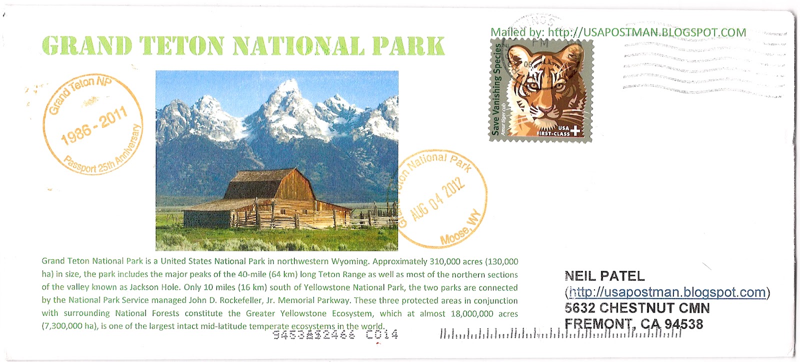
I send cover to myself  and my collection mentor ( polpostman and rainbowstampclub) with rubber stamp of Grand Teton NP.

This cover has 55 cents semi-postal stamp (charity stamp) - 11 cents more than First-Class Mail stamp for helping to save vanishing species  — specifically tigers, African and Asian elephants, rhinos, great apes and marine turtles.

Also there is a stamp of Grand Teton.!!


Tuesday, August 14, 2012

Things To Do In Jackson Hole, Wyoming : My Trip, Day 1

Arch of Elkhorns
 I Recently Made a "road" trip to various national parks and monuments. My first stop was old-town Jackson Hole, Wyoming. Jackson is a town located in the valley of Jackson Hole. It was named after  David Edward Jackson,  a fur trader. Due To its proximity to Grand Tetons National Park, Jackson Hole is a tourist haven. It is filled with quaint, olden styled  stores selling everything from curios to t-shirts to boots. Our original plan was to drive through Jackson Hole and head to Grand Tetons.


However, the lure of old town was too great and we decided to spend a little time to explore the meandering roads. A major attraction is the Series of Elkhorn Arches located in what could be considered The main square, seen on the postcard above.

I mailed myself a couple other postcards from Jackson Hole  which clearly show how much of Jackson Hole is affected by the nearby national parks and the wildlife they contain, although in a good way. Jackson Hole Just Likes to have a lot of  fun!


This postcard was mailed from Jackson Hole but it has automatic cancellation from Rock Springs, Wyoming which is 180 miles from Jackson Hole.!!

This postcard has 55 cents semi-postal stamp (charity stamp) - 11 cents more than First-Class Mail stamp for helping to save vanishing species  — specifically tigers, African and Asian elephants, rhinos, great apes and marine turtles. 


The net proceeds from the sales of the new Save Vanishing Species semipostal stamp will be transferred to the U.S. Fish and Wildlife Service to support the Multinational Species Conservation Funds.


Friday, July 20, 2012

Point Reyes National Seashore


     As the cancellation shows, this postcard was mailed from the Point Reyes Lighthouse.   
  
     Point Reyes is a popular Northern California tourist destination on the Pacific coast. It is approximately 30 miles  Northwest of San Francisco. As characteristic of the area, it can get very foggy and windy during certain parts of the year . To be effective, the lighthouse had to be situated below the characteristic high fog. When foggy, visibility is so slim that one cannot even view the lighthouse from the top of the approximately 300 steps necessary to walk down to reach it. The lighthouse serves a great purpose in such a foggy area, as there is no beach to wash up on; it is on a rocky cliff. Day or night, the light may be the only thing visible to ships.
     Point Reyes is also historically important as the landing site of Sir Francis Drake. On June 17, 1579, he became the first European explorer to land in Northern California,  and proclaimed it Nova Albion (New England).


Thursday, July 12, 2012

Chesapeake Bay Bridge : Postcard USA

The Chesapeake Bay Bridge (commonly known as the Bay Bridge) is a major dual-span bridge in the U.S. state of Maryland. Spanning the Chesapeake Bay, it connects the state's rural Eastern Shore region with the more urban Western Shore. The original span opened in 1952 and, at the time, with a length of 4.3 miles (6.9 km), it was the world's longest continuous over-water steel structure.  


Monday, July 9, 2012

Last Great Race on Earth : Mail carried on Dog Sled : Iditarod 40th Anniversary Cover : USA Cover


The Iditarod Trail Sled Dog Race is an annual long-distance sled dog race run in early March from Anchorage to Nome. Mushers and a team of 12–16 dogs, of which at least 6 must be on the towline at the finish line, cover the distance in 9–15 days. The Iditarod began in 1973 as an event to test the best sled dog mushers and teams but evolved into today's highly competitive race.


Teams frequently race through blizzards causing whiteout conditions, sub-zero temperatures and gale-force winds which can cause the wind chill to reach −100 °F (−73 °C). A ceremonial start occurs in the city of Anchorage and is followed by the official restart in Willow, a city in the south central region of the state. The restart was originally in Wasilla, but because of too little snow, the restart was permanently moved to Willow in 2008. The trail runs from Willow up the Rainy Pass of the Alaska Range into the sparsely populated interior, and then along the shore of the Bering Sea, finally reaching Nome in western Alaska. 


The trail is through a harsh landscape of tundra and spruce forests, over hills and mountain passes, and across rivers. While the start in Anchorage is in the middle of a large urban center, most of the route passes through widely separated towns and villages, and small Athabaskan and Inupiat settlements. The Iditarod is regarded as a symbolic link to the early history of the state and is connected to many traditions commemorating the legacy of dog mushing. (Read more at Wikipedia.)

Thanks Dad for sending me this nice cover with special cancellation. Readers, My dad is Gandhi Stamp collector and his  blog is http://gandhistampsclub.blogspot.com


Above cover has trail map from where this race pass and also has 2 stamps and special cancellation of Iditarod from Anchorage Alaska.

1) 4 cents Gandhi Stamps issued in 1961
2) 42 cents Alasks Stamps issued in 2009 to celebrate the 50th Anniversary of Alaska statehood is celebrated with an image of a dog sled team.

Tuesday, July 3, 2012

Mail carried by a Pony!! 600 riders, 1966 miles from California to Missouri. - USA


The Pony Express was a fast mail service that crossed the Great Plains, the Rocky Mountains, and the High Sierra from St. Joseph, Missouri, to Sacramento, California. In service from  April 3, 1860 to October 1861. It became the west's most direct means of east-west communication before the telegraph and was vital for tying California closely with the Union just before the American Civil War.


The National Pony Express Association conducted a Re-Ride of the Pony Express Trail from Sacramento, California, to St. Joseph, Missouri, June 13 - 23, 2012. This Re-Ride was   a 10-day, 24-hour a day, non-stop event by over 600 riders and horses over the 1,966 mile route of the Pony Express National Historic Trail from California through Nevada, Utah, Wyoming, Colorado, Nebraska, Kansas to Missouri. It is the longest event held annually on a historical trail in the nation.


Wednesday, June 27, 2012

USA : International Day of Peace : Gandhi Stamps Club

The International Day of Peace, also known as the World Peace Day, occurs annually on 21 September. It is dedicated to peace, and specifically the absence of war, such as might be occasioned by a temporary ceasefire in a combat zone. 

It is observed by many nations, political groups, military groups, and peoples. The first year this holiday was celebrated was 1981.


Thanks Dad.
Send to me by : Gandhi Stamps Club (http://gandhistampsclub.blogspot.com/)

Sunday, June 3, 2012

New York : Statue of LIberty & New York City.

The Statue of Liberty Enlightening the World was a gift of friendship from the people of France to the people of the United States and is a universal symbol of freedom and democracy. The Statue of Liberty was dedicated on October 28, 1886, designated as a National Monument in 1924 and restored for her centennial on July 4, 1986.

Height
151 feet 1 inch (46 meters)
Ground to torch: 305 feet 1 inch (93 meters)


The statue is situated in Upper New York Bay on Liberty Island, south of Ellis Island. Both islands were ceded by New York to the federal government in 1800.As agreed in an 1834 compact between New York and New Jersey that set the state border at the bay's midpoint, the original islands remain New York territory despite their location on the New Jersey side of the state line. Land created by reclamation at Ellis is New Jersey territory.


Entrance to the Statue of Liberty National Monument is free, but there is a charge for the ferry service that all visitors must use, as private boats may not dock at the island. A concession was granted in 2007 to Statue Cruises to operate the transportation and ticketing facilities, replacing Circle Line, which had operated the service since 1953.

The ferries, which depart from Liberty State Park in Jersey City and Battery Park in Lower Manhattan, also stop at Ellis Island, making a combined trip possible. All ferry riders are subject to security screening, similar to airport procedures, prior to boarding.

The statue, pedestal, and base are presently closed for renovation work. When the structure is open, visitors intending to enter the statue's base and pedestal must obtain a complimentary museum/pedestal ticket along with their ferry ticket.

 Those wishing to climb the staircase within the statue to the crown purchase a special ticket, which may be reserved up to a year in advance. A total of 240 people per day are permitted to ascend: ten per group, three groups per hour. Climbers may bring only medication and cameras—lockers are provided for other items—and must undergo a second security screening


Want to know Fees & Reservation information. Check following link.

http://www.nps.gov/stli/planyourvisit/feesandreservations.htm


Saturday, June 2, 2012

9-10-11 cover from USA

Thanks Dad for making sure about this one time date 9-10-11.


It's cool

Send by Gandhi Stamps Club (http://gandhistampsclub.blogspot.com)